
 I’m sure most of you have checked out Google Earth already. Google Earth is a virtual globe program that provides satellite maps and images to interact with.
Apart from being able to zoom into famous sightseeing places like the Las Vegas Strip, Miami Beach, the Mount Everest, you can even search for addresses, enter coordinates or just browse to locations of interest like your home town, your place of work or that special place in your memory, where you got your first kiss. ![]()
Unfortunately not all locations are digitized and rendered in a good resolution, so sometimes the level of detail is less than satisfying. On top of that you have sometimes clouds blocking the view to the ground. The software isn’t perfect either, as sometimes the sea levels are shown to high, which leads to mountains or higher areas are overspilling with ocean water, the most favourite location being Gibraltar, as mentioned by Wikipedia.
Nevertheless it’s an amazing and interesting tool, which can lead to interesting views. It gives travelling at your desk a whole new dimension.
So what’s the news?
With Version 4 of Google Earth a new feature was added, you can now practically change the ‘view from the top’ to a 3D image of the area, as height information was added. This leads to stunning effects, which are especially interesting for world travelers.
Just to give some examples I added here some of my recent destinations: right out of Google Earth and in comparison with a ‘Life Photo’ from the same location of the real spot.
How does it compare to real life?
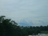
 Let’s start with Lake Batur, a nice spot close to Bali’s highest peak Mount Agung.
If you go there via Google Earth, this is what you can see, when switching into the 3D mode.
And now let’s see a real photograph of same viewpoint right at the entrance of this crater lake.
Pretty close, hm? Only the sea levels behind the Google Earth Image are a bit too high, this could be the above mentioned error, or the set viewpoint wasn’t low enough. Still I was quite impressed to see a very common sight.

Now imagine that you can do that from your desk and go to any location on this planet to check interesting places out! Of course it even looks better, the higher the differences are in altitude.
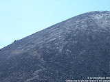
 Another famous site is the Kata/Karon Viewpoint in Phuket/Thailand. Every day of the year you can see hordes of tourists having a great view from this hill at the southern part of the Phuket Peninsula.
What are they looking for?
It’s mainly the unique combination of the 3 sandy bays Karon Beach, Kata Beach and Kata Noi Beach with their blue waters and white powdery sands. Truly magnificent!
 How do we rate in Google Earth?
Okay the resolution here isn’t so good, but still you’ll know what I mean and what makes this spot so interesting. I admit the photo to the right doesn’t show the exact same location, maybe because I chose the Google Earth Angle somewhere to much in the trees, where you can’t go with your camera. ![]()
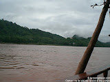
 At the end one example which shows the little flaws and limitations, which come with the software, mainly clouds and lack of vegetation in the Google Earth images.
Here is a picture of Mount Agung from a viewpoint around Candidasa in Bali, which looks nice with almost clear blue sky and palm trees in front of the mountains.
The same image from Google shows the same mountain cone, but of a “snowy” mountain, which isn’t possible just a few hundreds of kilometres south of the equator. ![]()
 Hah???
Of course this isn’t snow – but clouds. And vegetation isn’t height-measured, which is correct, but will give you an distorted image of the surrounding.
Instead you can see rivers or streets, due to the fact, that the photo was taken from a 90 degree angle straight from the sky and only re-calculated into the shown position.
So obviously even Google Earth has still some way to travel! ![]()
or save article to your Facebook with 1 simple click:
February 16th, 2007 at 4:10 pm
Google Earth is very useful. Undeniably it helps our traveling life easy
February 26th, 2007 at 9:53 pm
very helpful. and especially for my visitors who need direction to the nearest track. cool gadget!
April 11th, 2008 at 4:33 am
=))I don’t think it’s any good without an apple computer you can’t get the software
May 4th, 2008 at 6:16 am
Excellent work – highly commendable.
However, I must pick you up on one point; i.e. snow capped peaks do in fact exist on and near the equator. Some examples – Mt Kenya, Mt Kilimanjaro, Mt Stanley (all in Africa), and in the Equadorian Andes (South America).
Cheers,
Peter B.
May 5th, 2008 at 7:02 pm
Your are right Peter B, guess I generalized too much. :D
May 6th, 2008 at 5:29 am
Cheers for that Chris. As I long time GE user, and a keen traveller, I frequently check out where I have been, and where I plan (or dream about) going in GE, as well as following international news stories “on the ground” – so to speak. Have also started using Panoramio website to geolocate some of my travel pics in GE, which is fun and interesting – well worth a look.
July 26th, 2008 at 8:31 am
i would have much less criticisms. if you understood slightly how the software worked you would know how impossibly amazing it is already. accounting for vegetation height would be impossible, and images are already carefully selected to be free of clouds. remember they had to piece together the entire world. the software makes near perfect use of the information provided. it is the limitation of satillite technology that makes the imperfections in elevation and resolution. and you forgot to mention what makes it most useful to travelers. wikipedia articles about places are placed in the real location throughout the world, as well as panoramia pictures. these are pictures that people can upload and place in google earth where the pictures were taken in real life.
July 26th, 2008 at 6:23 pm
Greg, I’m sorry to have disappointed you. The problem for me with Google Earth is, that the data is quite old, for instance for Bali all satellite data is from 2003 and older. The rest of Asia doesn’t look any better, maybe except big cities like Singapore or Hong Kong. And the clouds ARE really annoying.
So, it would be useful for me to learn to use the software better, like you said. Can you help with that? How do I get more current data in it and what would you recommend to add/change in the above article? This way all readers could benefit and we’d learn something along the way….
April 5th, 2009 at 10:58 pm
=D> =D> =D> =D> =D> =D>
its helps when your far from home
just make focus to map and youlllllll see the streets and the city wer you came from….. :D
March 2nd, 2010 at 6:06 pm
For travelers with a laptop please note
…Google earth is a cache stored PC based program, it can be invaluable at times while traveling ……if you map out your travels, streets, locations using Google Earth then zoom in to each and every point you have recorded….then you no longer require the Internet to view it… as it is all stored in the memory of your PC …try it ….GEO